-
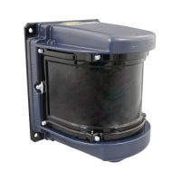
HOKUYO UXM-30LXH-EHA
Category: LIDAR / Laser ScannersThe UXM-30LXH-EHA is an outdoor-rated 2D LiDAR sensor used for STS crane positioning, container profiling and determining the location of trailers, AGVs or straddle carriers at ports and terminals. Equipped with an Ethernet interface, it can obtain measurement data in a 190° field-of-view up to 80 meters. It offers reliable detection of dark colored objects with no effect on scanning performance due to dust, condensation or scratches on the hard-coated lens. The integrated multi-echo feature ensures accurate measurement results in adverse weather conditions.
-
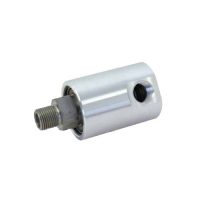
1/8″ to 1/2″ Air-Hydraulic Unions
Category: Rotating Union / Rotary Joint- Monoflow design
- Self-supported rotating union
- Radial housing connection
- Balanced mechanical seal
- Seal combinations: Carbon Graphite/Hardened Tool Steel or Carbon Graphite/Silicon Carbide
- Felt oiler in seal cavity for air service
- Oiler for relubrication (3 – 5 drops/month)
- Low torque
- Weight-optimized design
- Aluminum housing
- Bearings lubricated for life
-
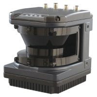
HOKUYO UGM-50LXP (Outdoor-Rated)
Category: LIDAR / Laser ScannersThe UGM-50LXP is an outdoor-rated 2D LiDAR sensor used for horizontal and vertical monitoring, area mapping, localization and obstacle detection. Typical applications include industrial AGVs, agricultural vehicles, mining equipment and port and crane automation. Equipped with an Ethernet interface and multi-echo function, measurement data can be obtained in a 190° field-of-view up to 120 meters. With an IP67 shock-resistant aluminum housing and built-in heater, this robust laser scanner provides reliable object detection and profile measurement under challenging ambient conditions for indoor and outdoor applications.
-
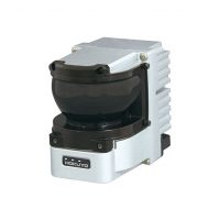
HOKUYO YVT-35LX 3D LASER SCANNER – 3D Scanning Range Finder
Category: LIDAR / Laser Scanners3D Scanning Range Finder. The distance is measured by steering the laser beam vertically and horizontally.
This scanner uses pulsed laser beam with TOF principle to measure distance. A laser beam is emitted in a wide 3D field providing access to hight, width and depth information of objects.
In 1 frame, a point cloud with 2590 points is generated. It is possible to increase the point cloud density using the interlacing mode.
This scanner is equipped with an acceleration sensor and a PPS input signal.
MALAYSIA OFFICE
18, Jalan BPU9
Bandar Puchong Utama
47100 Selangor,
Malaysia
Tel: +60 3 5891 1918
Fax: +60 3 5891 1919
Email: sales@technical-avenue.com
SINGAPORE OFFICE
18 Boon Lay Way
#04-118 Tradehub 21
Singapore 609966
Tel: +65 8777 2818
Mobile: +6012 402 2818
Email: sales@technical-avenue.com
THAILAND OFFICE
Sentech Industries Co., Ltd.
43 Soi Rangsit-Pathumthani 12,
Prachathipat,Thanyaburi,
Pathumthani 12130,
Thailand
Tel: +66 2 567 4592
Fax: +66 2 958 4014
Email: sales@sentechindustries.com
VIETNAM OFFICE
Technical Avenue Co. Ltd
First Floor, No. 9, Road 27,
Van Phuc Riverside City, Hiep Binh Phuoc Ward, Thu Duc City,
HCMC, Vietnam
Tel: +84 896648466 (sales)
Tel: +84 888089582 (admin)
Email: salesvn@technical-avenue.com